Tuesday, September 10, 2013

Day 5 - 0 for 4 Sign Him Up

Sheridan, WY to Red Lodge MT  284 (Round about, Garmin, *&^%&^ miles
September 10, 2013

(Click to Enlarge)

Up early but in no hurry this morning, I have a short ride today. 

Not sure what's going on with my GPS but it believes the fastest way to get to the Rosebud Battlefield State Park (B) above, is the route shown.  It's almost a 100 mile round trip from where Hwy212 joins I-90.  According to mapquest (after the fact...yeah, I know, stupid) there is a 37 mile route from Sheridan through Decker, WY on Hwy338.  I been Garmined...again.  But that's not all the bad news about getting to Rosebud Battlefield.  When I reached the road to go to the park I was looking at 2 1/2 miles of pea-gravel.  Nothing wrong with pea-gravel, unless you want to stop.  Then it's the equivalent of stopping on ball bearings.  Betsy don't do pea-gravel except in very short stretches.  Nothing short about 2 1/2 miles so, you guessed it, I turned around and headed back to Little Bighorn Battlefield National Monument.


The site is a U.S. Military cemetery with veterans (and spouses) from many wars, predominately WWII.  But a lot of the graves are those of troops killed during the various Indian Wars including the troops from the Fort Fetterman Massacre.


But, of course, the big deal here is Custer's Last Stand.  On 25 June 1876 Custer led his 7th Calvary consisting of approximately 600 troopers and scouts into the Valley of the Little Big Horn. His scouts reported locating an Indian camp early on that morning.  Custer, significantly underestimating the size of the encampment and the number of warriors potentially present made one of the cardinal errors of the military art.  He split his forces, retaining 5 companies and sending 3 companies each with Maj. Marcus Reno and Capt. Frederick Benteen.  Benteen was to scout the bluffs to the south while Custer and Reno headed toward the village.

Near the river Reno was ordered to cross and attack while Custer and his troops continued northward to halt any retreat of the villagers in that direction.  Reno was attacked by significant numbers of warriors.  Realizing he was vastly outnumbered he dismounted and formed a line of battle.  Unable to hold and quickly outflanked, Reno was forced to retreat "in disorder" (read: run like hell), and take up defensive positions on the bluffs above the river.  He was joined by Benteen who had hurried forward under orders from Custer to "Come on; Big village, be quick, bring packs."

Whenever the fighting lessened in his front Reno sent an advance company under Capt. Thomas Weir in an attempt to determine Custer's location.  Advancing about a mile Weir crested a high hill from which he could see the area now known as Last Stand Hill.  At this point there was no firing from that quarter.  In fact, the Indians, regrouping, turned and attacked up the hill on which Weir was holding.  After coming under attack there, Reno pulled the troops back, and his and Benteen's  companies joined with the company assigned to guard the wagon train and returned to his original retreat position on the bluffs overlooking the Little Big Horn.  There they successfully withstood attacks and discouraged further forays by the Indians through this and the next day.  The seige lifted when the Indians learned of Gibbon's approach from the north.


The next two pictures probably give the best idea of that the terrain was like where this battle was fought.


High grass with little cover.  No place to run, and little in which to hide.


This is the view from the bluffs above the Little Big Horn from which Reno was able to hold  until the siege was lifted.   He first entered the valley from about a mile to the left.

Looking further to the right is the area across the river where the Indian "village" was located.  It was one of many.  Spread out further along the river were the  "villages" of Uncpapa, Blackfeet, Brule, Oglala, Minniconjou, Sans Arc, and Northern Cheyenne.


About a mile further to the right Custer led his 5 companies down an escarpment called Medicine Tail Coulee pointing directly at a ford across the Little Big Horn.  At this point he would have been able to see "all" the villages present. There are disputes about what he did at this point, but it is obvious what he didn't do: He didn't make the connection between the numbers of teepees and the possible force of braves he might face.  A prudent commander would have and, I think, turned back to unify his force in the face of such opposition.

Given his predilection for the attack and his stated goal of circling and stopping a retreat from the villages to the north, there is good evidence he split his force YET AGAIN(!) sending Companies E and F to try to cross the ford, leaving himself with Companies C, I, and L on the ridge as support and, equally important, as a rallying point for Benteen who he had ordered to "come quick."

By this time, the forces coming at him from the villages were many and close, I believe, forcing his two companies at the ford back up the hills and instituting a running fight to the end.  His remaining forces temporarily re-united at Calhoun Hill where another skirmish line was established by Company L under Lt. James Calhoun.  This probably gave some small relief to Custer and his troops in their flight toward the highest ground they could find, but it didn't last long.  The position was overrun with the further disaster of the company's horses being scattered trapping them there to their destiny.  But the end is near now.  Custer and his command  reach Last Stand Hill.  Capt. Myles Keogh's Company I and remnants of C Company were cut down by Crazy Horse and White Bull on Battle Ridge while attempting to join with him there.


The site at Calhoun's Hill where Company L formed a skirmish line.  Their horses were held in a small ravine just over the hill to the left.
There is a large grouping of headstones near the bottom of the hill.


A closer view.


The picture above makes the point about a running battle taking place here.  To the far right is the grouping of Company L headstones.  You can see the line of markers coming up the hill toward this position on the side of Last Stand Hill.  It had to be unbelievably horrific for those troops.


Custer and about 41 of his men are isolated and under fire from many positions.  Killing their horses for use as breastworks they make a stand.  Custer, his brother, Tom, and Lt. William Cooke are found near the site of the 7th Calvary Monument now erected at this site. 

This monument is just behind the grave sites shown above indicating where Custer fell.

There can be little doubt that Custer overestimated the capabilities of his command, and underestimated those of his opponents.  Additionally, he made the often fatal mistake of ignoring intelligence reports regarding the strength of the forces arrayed against him and then split his forces at least twice during the battle.  Those brave troops deserved much better leadership than that.

Monday, September 9, 2013

Day 4 - 0 for 3 (Eligible for Astros Batting Order)

Cheyenne WY to Sheridan WY - 325 Miles
September 9, 2013

(Click to Enlarge)

Got an early start this morning.  Up, finished breakfast and on the road by 7:15am.  Cloudy, overcast morning, but blessedly cool after the front came through.  So cool, in fact, I decided I needed to armor up.  Looking at the sky I decided I'd probably run into a few showers so on with the riding togs and the rain togs.  It's a measure of how cool it was that I was snug as a bug even when the sprinkles began.  Never felt one drop of water except when I raised the helmet shield to see if it was still sprinkling hard enough to keep it on.

The day was cool, and I had the great Wyoming scenery to view.


Wind sculpture


My planned stop today was Fort Fetterman just north of Douglas, WY.  The fort was created on the south side of the North Platte River in 1867 and was a major jumping off point for several major military expeditions against warring Indian tribes.  The fort was named for Captain William J. Fetterman, a veteran of the Civil War who, seemingly like Custer, was more enamored of his and his troop's abilities vis-a-vis the Indians than elemental caution would dictate.  Like Custer, he paid with his life, taking 80 of his troops with him in 1866. (See: Fetterman_Fight)

In May 1876 three forces converged to attack the Sioux; from Fort Ellis in the west the Montana Column was led by Colonel John Gibbon, from Fort Abraham Lincoln in the east the Dakota Column, containing the 7th Calvary (Custer), was led by General Alfred Terry, and, from Fort Fetterman in the south, 15 companies (~1000 men) led by General George Crook, The Yellowstone Expedition, marched on 29 May.

My reception upon reaching Fort Fetterman.


Perhaps this is more clear.


Didn't matter.  I usually pay the day fee to walk around the site and see the views the participants had back in their time.

View of the terrain from the entrance of the fort.  Betsy had seen enough, so we moved northward again.


Pulled into Sheridan about 3:30pm, the early stop dictated by "Laundry Nite." 

Sunday, September 8, 2013

Day 3 - Record Intact...Another Failure

Lamar, CO to Cheyenne, WY - 299 Miles
September 8, 2013

(Click to Enlarge)

Woke to bright sunshine and a watch that said 7:01am.  Thought something was wrong until I realized that it was only 6:01am and that sun out there was up only because I was in the eastern end of this time zone.  But I was up so I read a little and killed some time.  My intention was to visit the  Sand Creek Massacre National Historic Site and I figured they wouldn't be open until 09:00 so there was no hurry. 

After a nice breakfast, I gassed up and headed out following my trusty Garmin GPS.  I have a new one, that old lying s.o.b. I had before gave up the ghost before I made him one myself.  (Must be the unit, couldn't possibly be me.)

This area is high plains.  Miles and miles of miles and miles; mostly in the process of producing something from the land.  Boring, until you consider their shear vastness.  In their own way they are as majestic as the Grand Canyon.

One of my favorite things is lots of road with no one on it but me.  I love to hog the miles and miles and Colorado is one of the best places in the country to find such opportunities.

                         Looking south 


Looking north

 Beautiful day, huh?

I'm always amazed at the things you run into on these rides.  Riding merrily along, contemplating the middle east and North Korean problems, and wondering about the next Oracle EBS Release...YEAH RIGHT!  Enjoying the cool morning and Betsy's throaty rhythmic metronome I looked up and saw a car on top of a silo.  Yes, I did.

A rather meager attempt if the goal was to emulate "Carhenge" in Alliance, Neb.
(From White States Ride 2007: Carhenge)

Okay, now for the disappointment.  As noted, my intent was to visit the Sand Creek Massacre National Historic Site.  For the non-history buffs among us, this was the site of the massacre of between 70 and 163 Cheyenne and Arapaho, most of them women and children, along Sand Creek in southeastern Colorado on 29 Nov. 1864.  The raid was led by Col. John Chivington a Methodist minister cum Colorado Volunteer Army Colonel.  His relish for the latter led to his "location" (read: firing) from the former.  Among his most confusing contradictions was his zeal as an abolitionist and his hatred of the native Americans.  (My opinion: he was overly proud, arrogant, and ambitious...traits shared by many today.  Like Pat Robertson, evidently Chivington's Bible had only nine commandments too.)  But, as so many, he was politically astute and knew how to rabble-rouse.  At least until he couldn't fool anyone any more.  His political life essentially died after he seduced, then married his dead son's wife.  Who latter divorced him for non-support.  Nice guy, what?

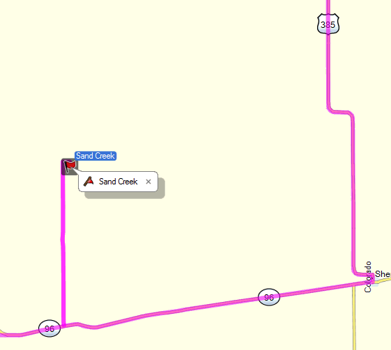
All of the above is to provide background for my inability to get to the Sand Creek Massacre National Site.  The below map will illustrate my problem.
This section is from my GPS trip planner for the visit to Sand Creek.  What this, nor mapquest, nor Google earth will tell you is that little blip up from Hwy96 to the site is eight (8) miles of unpaved, sand and gravel road with the consistency of a No. 4 washboard.  I rode about a mile of it and recognized that Betsy would have zero tightened screws and bolts, and I would have zero fully attached teeth in my head if I continued.  I didn't.  It's pretty obvious that the State of Colorado is justly embarrassed by this particular moment in their history and isn't about to provide decent egress into the facility that exists primarily to point out one of the darkest moments of their history.  Just as an aside, there is a town named after Chivington just past that first "96" marker on the map and it is dead as he is.

Disappointed, I soldier on heading north into Wyoming.  Weather reports indicate some Canadian air coming over the next couple of days, something to be embraced.  However, that also means rain and let me tell you, when it rains out here around the mountains, it rains.  I turn westward toward Greely then north to Cheyenne on Hwy85 avoiding all but a short span of slab (Interstate).  It turned into a race.

Off to my left as I head up Hwy85, apparently almost directly over I-25 running parallel to me I see this.  You can't tell from this distance, but I can just about guarantee you it's strangling frogs over there.  Not interested in such things, I pull into Cheyenne and park it for the day.


Day 2 - Blanco Canyon

Abilene, TX to Lamar, CO - 511 miles
September, 7 2013


As usual on my rides I wake up the rooster and lay in bed waiting for the sun to make its appearance.  On the road with a light motel breakfast by 7:15am motoring almost due north.  Couple of hours later I'm approaching Crosbyton, TX just east of Lubbock.  When you say Lubbock to me I think of cotton fields...immediately after flashing on Buddy Holly, Waylon Jennings, and Lloyd Maines...and flat land.  But it's not.  Like the grand canyon it gets "hilly" downward.
 
About twenty miles from Crosbyton I see my first "down."  It's called "Putoff Canyon" after an early settler.  It was known for its abundant fresh water "strong enough to swim a horse."


Further on you start to see where the water runoff that created Putoff Canyon has joined with a larger stream to form yet a larger canyon.  This is Blanco Canyon.

Dry now due to pumping, the fame of the canyon comes from the White River water and considerable timber, scarce in the area, which grew here into the 20th century.


.
In the 1990s it was confirmed that Spanish Conquistador Francisco Coronado camped here twice in the spring of 1541.  He was, I supposed, busy losing horses,  It's amazing to me how quickly the horses multiplied after the early Spanish reintroduced them to this continent.  It certainly changed the lives of the Plains Indians tribes.

It's the Plains Indians we're interested in...specifically at this stop, the Comanches.  It was here in 1871 that Col. Ranald Mackenzie led his San Angelo-based troops.  The battle fought here barely deserves the name "battle."  Mackenzie lost one trooper and reports indicate a couple of Comanches were killed.  But the significance of the encounter is it was the first real move against the Comanches after the Civil War.  Setting up a supply camp at the mouth of the canyon Mackenzie essentially served notice that the war was on.  Three years later he caught the Comanche, Kiowa, and some Cheyenne north of here in Palo Duro Canyon.  He captured their entire herd of horses (some 1100) and destroyed their tents and supplies...in September, just before winter set it.  It forced them into reservations to survive.

An interesting note, at least to me, is Mackenzie seems to be able to get a lot accomplished with  few casualties.  He lost one man at Blanco Canyon and one at Palo Duro.

It's just open farm country now, only pretty when you are in it and can see the fertility and richness of the land, and the wide open spaces.  But, at one time, it was where cultures clashed.  For any looking for some great sympathetic treatment of the "noble" Redman you'll have to look somewhere else.  The white man came here and took the land from the Comanche and Kiowa.  They'd taken it from the Apache.  I can determine no fine distinction in the result.

But, time's a-wasting so I head north with the intention of revisiting Palo Duro Canyon.  I made a trip there back in 2009 because it always intrigued me.  But it got so hot by the time I was fairly near I decided to move on north looking for relief.  Didn't get it, though.  But I ate miles of road until  reaching Lamar, Colorado about 5:30pm (our time...they're "behind" us you know).

Took one of those "road showers" I harp about so much.  Seriously, one day I will write the definitive "Ode to the Road Shower."  It will be in iambic pentameter and explain, as only poetry can, how absolutely wonderful a long, drenching shower can feel after 8-10 on the road on the back of a motorcycle.


Saturday, September 7, 2013

Day 1 - Good Friends, Great Meal

Spring, TX to Abilene, TX  - 336 Miles
September 6, 2013


(Click to Enlarge)
Best laid plans and all that, I was going to leave early to avoid as much of the afternoon heat as I could...didn't work out that way.  I was late picking up drugs (that's prescriptions in geriatric terms) and then I discovered the batteries for my signal booster for my Sirius radio audio were toast.  Ever tried to find AAAA batteries early in the morning?  Going without was an unacceptable option.   Without that booster one can't hear Outlaw Country and the Blue channels at 80 m.p.h.  Thank God for Ace Hardware...they had 'em though it took twenty minutes to find them.  They are itsy-witsy little rascals, you know.

But I got out finally heading up Hwy290 to Hwy36 and then on into Abilene to visit my good friends the Criders.  I never miss an opportunity to stop by and visit with them.

How hot was it?  Near the Crider's home is a large dip down to a small dry creek crossing.  As I crossed the bridge I noticed a very large rattlesnake skin that had, obviously, been shed very recently.  As I wondered how big the thing was now, and where it was, I saw movement on the side of the road.  There, just off the side was the largest rattlesnake I've ever seen; totally nude and sitting in a chaise lounge with an ice-cold coke.  That's how hot it was.  I had little Emma's rapt attention as I related this story to the wonderful little 7-year-old. 

We went to this great little restaurant called the Copper Creek for dinner.  The food was quite good and WT's came with a Poblano Pepper Mac and Cheese that is absolutely to die for.  I'm going to figure out that recipe when I get home...cardiologist be damned.

Thursday, September 5, 2013

Heading Out Again

Betsy and I are pulling out in the morning for points west.  Current plans are to bear northwestward ultimately to Montana, visiting scenic and historic sites en route.  I hopefully plan to have a lot of pictures and commentary, assuming, of course, I can stay awake long enough to provide updates.